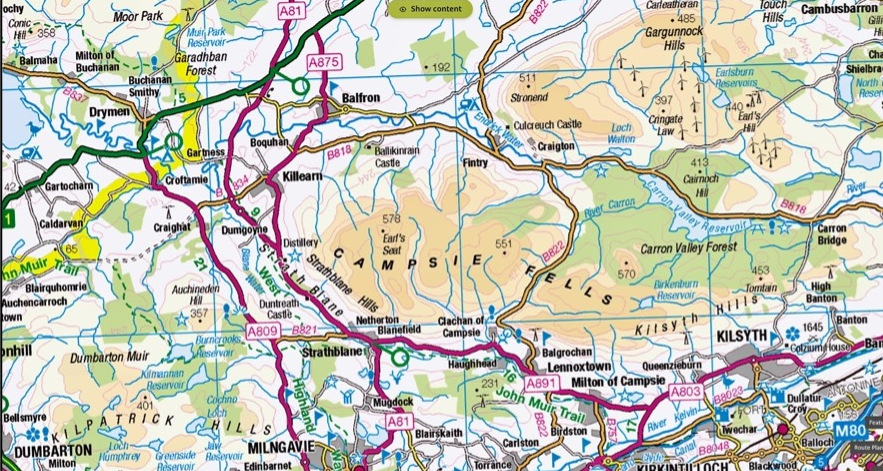
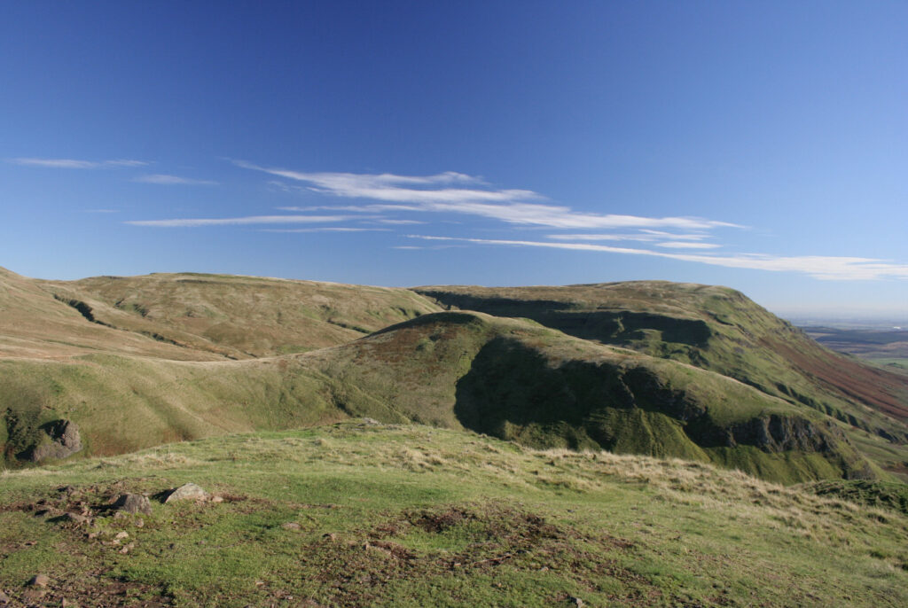
The Campsie Fells (‘The crooked fairy hills’) lie just a few miles north of Glasgow. They’re the highest and most extensive group of hills that form a more or less continuous range between Dumbarton and Stirling. To the west of the Campsies are the Kilpatrick Hills, to the north-east the Fintry and Gargunnock Hills and to the east the Kilsyth Hills. The highest points are Earl’s Seat (578 metres) and Meikle Bin (570 metres). The Campsies are not lofty in comparison to the hills and mountains further north, but nevertheless, their lowly standing masks several gems of mountaineering significance.
When I came to live in Scotland some 50 years ago, I had little interest in mountaineering, and the Campsie Fells, which overlooked my house in Blanefield, failed to inspire. But that changed as I learned of connections with Tom Weir, William Naismith and the Creagdhu Climbing Club. An even more interesting picture began to emerge when other associations - Monty Python’s ‘The Meaning of Life’, mountain lions, Michael Faraday, numerous aircraft accidents and development of the Scottish mountain rescue service - came to light.
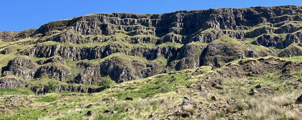
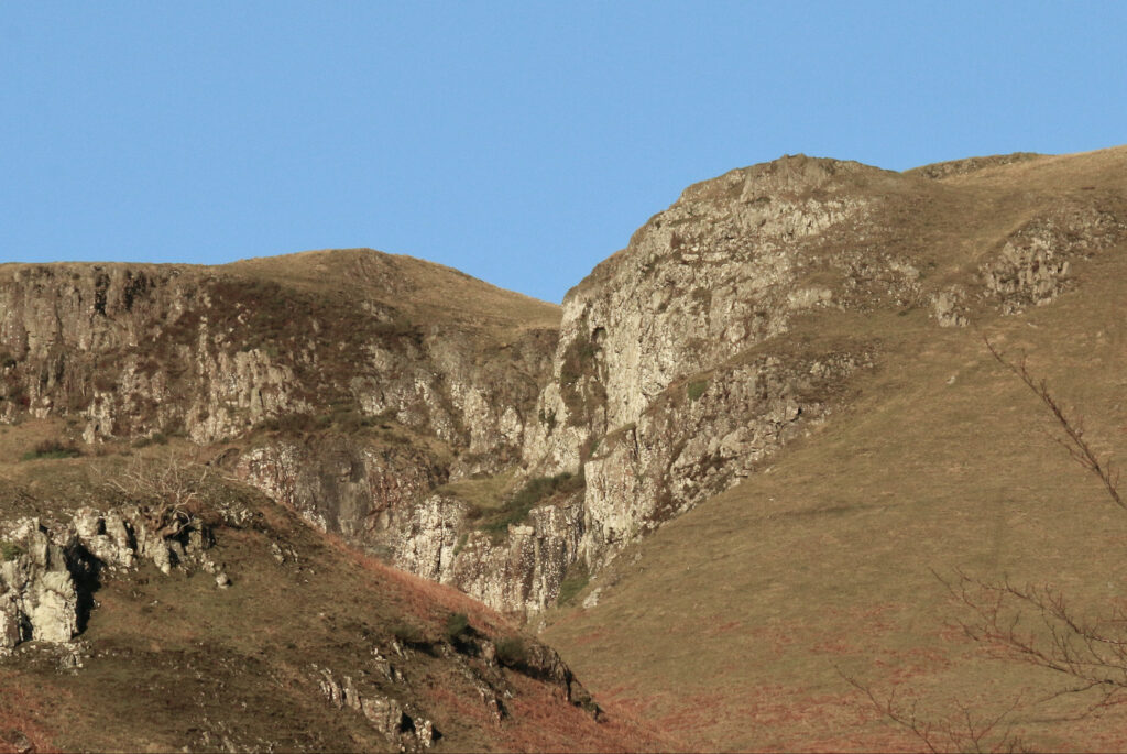
The Campsies lie just south of the Highland Boundary Fault and comprise a wide expanse of mudstone and limestone beds intruded by the accumulation of some 30 lava flows that date back some 300 million years. A succession of horizontal layers of rotten and broken rocks are clearly visible on the southern escarpment (Slackdhu) above Blanefield.

Some of the distinct rounded tops such as Dumgoyne (427 metres), Dunglass and Dumfoyne are the vent plugs of volcanoes that have weathered more slowly than the surrounding terrain. The junction of sandstone and lava often results is significant landslips: the one that took place in 2006 below Slackdhu, in which the ‘snout’ of the debris reached a height of around four metres, is the most significant one seen in modern times.
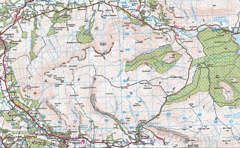
The escarpment to the north of the Campsies is steep and craggy in places and in winter conditions can hold snow well into spring. The Corrie of Balglass is a significant feature, regarded as a classic example of an armchair corrie. The southern boundary overlooking Blanefield and Lennoxtown, comprises several rocky escarpments broken by a number of obvious glens. Ballagan Glen and Fin Glen cut deep into the main plateau whilst the Crow Road (originally a drove road), which winds up Campsie Glen, effectively divides the Campsies into two sections. Ballagan Glen is home to a series of significant waterfalls including the Spout of Ballagan, which plunges over 20 metres when in full spate and is clearly visible from the road. The plateau rarely drops below 300 metres and for the most part undulates and is relatively featureless. Large expanses of peat bog, sphagnum moss and tussocky grass make challenging progress for walkers and there are few established paths.

So what do the Campsies offer in the way of outdoor adventure? For those interested in ski touring, the plateau has the potential to provide good sport with reasonable access both west and east from the Crow Road, although a fair depth of snow is needed to smooth out the tussocky grass and boggy sections.

Unfortunately, with rising temperatures and diminishing snowfall, there is little opportunity for worthy skiing. But turn the clock back fifty years and extensive snow cover was almost guaranteed and it wasn’t unusual to see the plateau crisscrossed with ski tracks. Even further back in the 1940s and 50s it is said there was a local ski scene in the Campsies. But significantly, if we go back to the late 19th century, it turns out the Campsies witnessed the very beginning of skiing in Scotland.
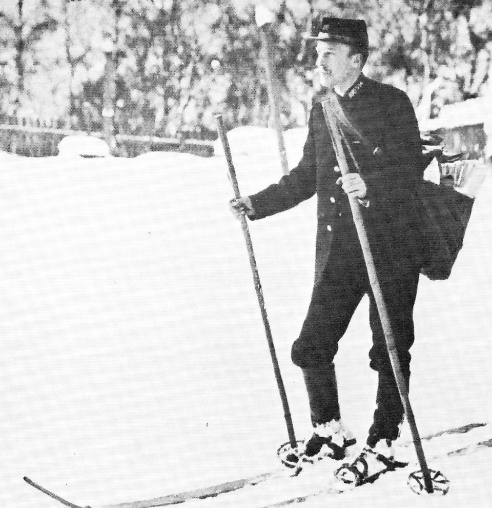
Distinguished mountaineer William Naismith was a key proponent. Naismith was a founder of the Scottish Mountaineering Club in 1889 and a key mountaineer of his day, whose first ascents included Tower Ridge on Ben Nevis and Crowberry Ridge (Naismith’s Route) on Buachaille Etive Mòr. Many readers will know of ‘Naismith's rule’, which he devised to estimate the time to walk a route of a given distance and elevation gain. Naismith was also a proficient skier and is reported to have made the first expedition on skis in Scottish history when, in 1892 he skied across the Campsie Fells. Myrtle Simpson who penned the definitive history of Scottish skiing, described his expedition, viz.,
“There was fresh snow on the hills on the 12th March 1892. W.W.Naismith and a friend boarded the train in Glasgow for Kirkintilloch, then caught the early trap to Milton of Campsie. Bystanders were surprised to see them shouldering long heavy planks of wood and setting off to clamber up to the snow behind the village.
“The wooden planks were ash skis, seven feet long and four and a half inches wide with leather fastenings. The young men fixed the straps over their heavy workmen’s boots and skied up onto the ridge before following the crest for two miles to a top known as Meikle Bin. It was a clear crisp spring day and the two men were thrilled with the view. The hills were glistening white, the sun sparkling off the fresh snow. Naismith could see right across Scotland, from the Ochils and Firth of Forth to the Arran Hills beyond the Clyde. They retraced their tracks, and Naismith found that a very slight gradient was sufficient to set the skis sliding at a tremendous speed. As the angle steepened, he kicked them off and sat on them instead, turning the skis into a toboggan. He could hardly wait till the next annual dinner of the Scottish Mountaineering Club to relate his experience.”
At that meeting Naismith gave an account of his day on Meikle Bin and pointed out to members that with skis they could range all over Scotland even in winter. He did say that skis were not much use on the ascent, but on level ground or on soft snow, better progress was made with them than without.

For walkers wishing to explore the plateau, access is limited. Although there are break points, the southern escarpment is steep and fragmented, although there’s a well-worn path from Glengoyne Distillery onto Dumgoyne, another route from Cantywheery (cottage) heads steeply towards the summit of Slackdhu, and there are others via Balagan and Fin Glens. There is access both east and west from the Crow Road near its summit and from the north, there are routes from High Lettre just south of Killearn and from the B818 directly south into the Coire of Balglass. There are others but these are the popular ones.
Whichever route is chosen, it’s fair to say that generally, walking on the plateau is not very satisfying; it is rough in places with tall grasses, boggy areas and few obvious paths. And given its featureless terrain, navigation in bad weather can be extremely challenging. Indeed, many walkers have come unstuck and on one tragic occasion two young men succumbed to hypothermia when lost on the high ground above Slackdhu.
Nevertheless, the walk along the pipe track from Blanefield to Killearn, the ascent of Earl’s Seat (from Dumgoyne, Fin Glen or the Crow Road), Slackdhu, and (from the Crow Road) Cort-ma-Law, Lecket Hill and Meikle Bin are all popular. Dumgoyne, by virtue of its isolated position and characteristic appearance, stands proud, commanding a clear view of Loch Lomond and the hills beyond. It’s a very popular but steep hill to climb not without risks of slipping/falling.
If the Campsie Fells played a key role in William Naismith’s exploration of the great outdoors, then Tom Weir was equally taken. Born in Glasgow in 1914, Tom was a broadcaster, author, mountaineer and environmentalist. He developed a lifelong affection for the hills as a child, commenting that his love of the Scottish landscape began when a young teenager living in Springburn. He is widely known for his travels throughout Scotland and for his many excursions on mountain ranges throughout the world, but it was the Campsies where it all began. Reflecting on his very first experiences, Tom said:
“The bus that ran past our door went straight to Campsie Glen. A single journey cost just 6d. From my house I could see the green outline of the Campsies and the blue skyline of far-away and bigger hills and decided I would go there. For me, the Campsies became the most wonderful place in the world.”
Today, there is a walking route up Campsie Glen and a cairn, both of which commemorate Tom’s vast contribution to Scottish outdoor life.
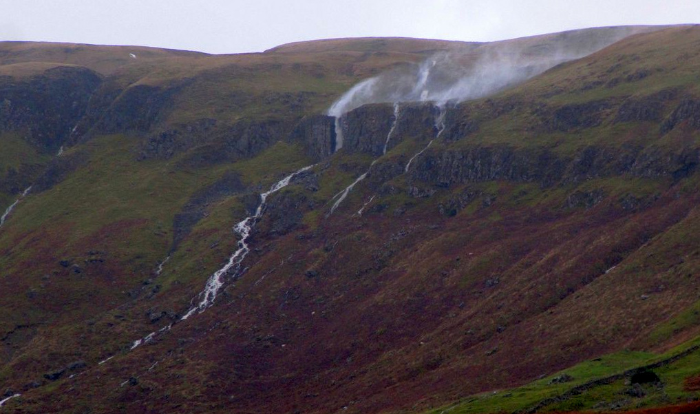
In regard to rock climbing, the steep escarpments and layers of exposed rock, especially above Blanefield and Lennoxtown suggest potential, but that is not the case. The rock is mostly unstable and although there are a number of named routes on the face of Slackdhu, they are rarely climbed. The best climbing is on a short outcrop near the south-eastern end of Slackdhu. A small stream cascades over the edge and in very wet weather becomes a significant waterfall that cascades down a 15 metre chimney called Jenny’s Lum. (It is named after Jenny Brash, who once ran an inn further down the burn. When there is a strong southerly wind, the cascade is forced upwards producing a spectacular spray that resembles smoke from a chimney.) The cliff to the left of the Lum is vertical and its north-western edge is called Jenny’s Lum Arete. Graded hard severe, the rock is solid but the holds are small and there is little or no prospect for protection: that is why most climbers rig a top rope. It’s a fine little climb and regarded as the classic problem on the Campsies. There are several other short climbs adjacent to the arete.


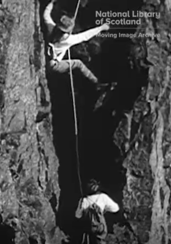
In 1958 The Ladies Scottish Climbing Club made a film to commemorate its 50th anniversary. It is a reconstruction of women climbers from 1908 dressed in Edwardian gear climbing Jenny’s Lum. Three ladies wear breeches and nailed boots under skirts, which are left at the foot of the hill before beginning the climb. There is a comedy sequence at the end where two women [Hazel Scott and Rona Dickson, later Mrs Tom Weir] dressed in 1958 style of climbing gear, meet the 1908 climbers. The film forms part of the collection of the National Library of Scotland Moving Image Archive at the Kelvinhall in Glasgow and can be viewed using this link: https://movingimage.nls.uk/film/2150?search_term=campsies&search_join_type=AND&search_fuzzy=yes
About 500 metres south-east of Jenny’s Lum is an obvious open gully to the right of which is a prominent crag called Black Craig. There are a couple of steep grassy ledges up the crag whose total height is about 50 metres. The rock is very loose and vegetatious, underlined by a report from 100 years ago suggesting that climbing the crag was “barely justifiable”. Although there are no details, in 1935 it was reported to be the scene of a tragic accident. However, it should be recorded that the crag played a very important role in the history of Scottish climbing. In his biography of legendary climber John Cunningham, Jeff Connor described an event that took place in 1930.
‘Slackdhu is the nearest thing to the traditional concept of a crag that the Campsies can muster from Kilsyth close to Cumbernauld in the east to picturesque Killearn, the stockbroker belt bolt-hole of Glasgow, on the A825 in the west. Subdivided by winding Broads into their geographical subordinates of the Touch Hills, Kilsyth Hills and Fintry Hills, the Campsies offer fine walks of easy gradient below the 2,000 foot contour - and all within a bus ride of Glasgow. But their crumbling dolerite outcrops and vegetated gullies are virtually worthless to the man with boots and rope.
‘Not that that deterred Andy Sanders when he set out from his home in Clydebank on a spring weekday in 1930. First he took a tram ride to rural Milngavie north of Glasgow then, with a companion tramped - clinker-nailed boots ringing on the tarmac - along the remainder of the A81 to the village of Blanefield above which Slackdhu and its conical outpost of Dumgoyne do their best, in their own modest way, to tower. It was a fine day and although in the past Sanders had used his thumb to hitch from Clydeside out into the hills north of the city, he and his mate were in no hurry; like some 120,000 other unemployed Glaswegians of that year, they had time on their hands. At Blanefield the two mountaineers turned right along the Campsie Dene road, hastened on tiptoe past the gamekeeper's cottage - Slackdhu like most of the Campsies in those days was on private land - and then stuck up the hillside towards the cliffs, just on the 1400 foot contour.
‘Sanders had been here before and the gap in his broad and often employed grin was the legacy of an earlier attempt on Coffin Gully, the deep black cleft in the centre of the crag, when a loosened rock hit him full in the face and removed a front tooth. This time his target was the two-tiered outcrop on the right of the escarpment and a route directly up its face which, after a struggle with loose rock, vertical grass and vegetation, eventually succumbed to the determination and bloody-mindedness of the two Clydesiders. It was as they were coiling their manilla line at the top that they noticed they had company: two doctors on their way south along the track from Earl’s Seat. Astonished to see two bodies clad in ill-fitted, buttoned corduroy lumber jackets and with baggy trousers tucked into puttees, emerge from the depths below, the gentlemen hikers hastened over and there followed something approximating the following conversation:
First doctor: "Good heavens man, have you just climbed up there?"
Sanders: "Aye, that's right, Jimmy, no' as hard as I thought."
First doctor: "But that has never been climbed before, it's a first ascent!"
Sanders: "Aye, well, that's as maybe, but it was good fun and anyway I dinnae even ken the name of yon crag."
It was then that the other doctor, who had remained silent until then but who was obviously a local expert, interrupted. "It's called the Black Crag," he said, "although some locals know it by the Gaelic name, Creagh Dhu."
It’s unclear exactly what happened afterwards (perhaps there was a meeting of like minds?) but there is no doubt that the Creagh Dhu Mountaineering Club saw its birth on this: “scruffy crag in the Campsies.”
If rock climbing on stable, dry rock is limited, there is better sport in winter after a good snowfall and several days of freezing temperatures. This happens infrequently but when it does, a frozen Jenny’s Lum makes a decent ice pitch and Coffin Gully, which (as Conner notes) divides Slackdhu, is a good Grade I route. Elsewhere, ice build-up on Slackdhu and the crags at the head of the Coire of Balglass makes for good technical practice. Also, walking is more appealing when the ground is snow-covered, although traversing acres of breakable crust can be frustrating!
On a rather dark note, there have been several aircraft incidents on the Campsies. Just north of the summit of Meikle Bin lies the remains of a Fairey Firefly that crashed in January 1950. On their way to RNAS Abbotsinch, the crew lost radio contact and failed to see Meikle Bin through the cloud base. Initially, the aircraft was reported missing and was the subject of a BBC radio appeal for information. Later, it was discovered that it had clipped the summit killing both crew members. Then in 1990 a Cessna 404 on flight from Aberdeen to Glasgow crashed just below the summit of the crag above Fintry killing both occupants; altimeter failure made it impossible for the pilot to judge height in the thick cloud. Just a few feet higher and the plane would have missed the hill top! A few years later in 1995 on a superb summer’s day, a hang glider pilot came to grief just below Slackdhu. He had launched from the top of the cliffs but his canopy collapsed when about 200 ft above the ground.
Significantly, a tragic incident in 1970 involving two boys aged 9 yrs and 10 yrs who had absconded from a special school near Fintry, had repercussions for the provision of mountain rescue in the area. It was thought the boys were sleeping rough locally or had hitched a lift to Glasgow, but in fact they had attempted to cross the Campsies in atrocious weather. Their bodies were found several weeks later in a snow-filled gully in the Coire of Balglass. From the very beginning, the recently formed mountain rescue team had offered to execute a thorough search of the plateau, but the team’s offer to assist was declined by the police in the belief that the team’s skills in searching mountain areas were not appropriate. This was a turning point for it didn’t take long for the team’s competence as a bona fide mountain rescue team with expert search capability to be fully recognised.
Walking, climbing and skiing aside, the Campsies are notable for a variety of curious occurrences. For example, it has been suggested the English scientist Michael Faraday came up with the theory of electromagnetic induction while lost on the Campsies in 1841. In the 1980s, Dumgoyne was the location for one of the Scottish hill races, often called the ‘The Dumgoyne Dash or ‘The Glengoyne Gallop’. The record up and down was recorded by Jack Maitland in 22 minutes and 8 seconds. A vivid description of the route was penned by Manna Gorman in 2014. Here is a snippet:
“If you like your running fast, technical and brutal, then this was the one. The slevering, colourful melee up and down this famous prominent 1,400ft volcanic plug at the south end of the Campsie Fells was held in trust by the best small-to-medium sized running club in the west-end of Glasgow, the mighty Westerlands CCC, but sadly only lasted ten years before the landowner withdrew permission. However, in that short time the race carved out a notch in the hard history of Scottish hill running, never to be forgotten and to be remembered by those who ran it with reverence, and a cold sweat trickling down the back of the neck.”
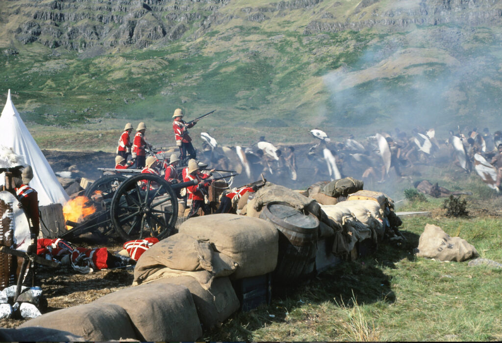
In 1983, the lower slopes of Slackdhu were used as the location for filming scenes of the Monty Python film ‘The Meaning of Life’. Apparently, the rocky backcloth made a very good substitute for the South African province of Natal during the first Zulu wars in 1879. Numerous locals were employed as extras to play the Zulus. The weather was fine but cold and one day the extras refused to wear their costumes as the weather was too cold; filming was abandoned for the day!
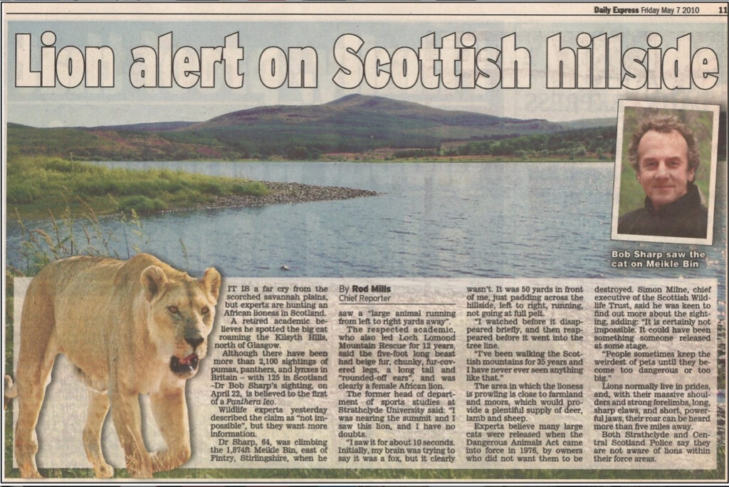
On an equally humorous note, a few years later in 2010, I headed up Meikle Bin starting at the west end of the Carron Valley Reservoir. High up, a path leads through the last of the trees and follows the north-west ridge to the 570-metre summit. Conditions were dry and the cloud base was well above the summit. The only other walkers I met that day were near the parking area. A perfectly ordinary outing until, on the final slope just below the summit, I saw a large animal moving from left to right about 20 metres away. Clearly, it was a female lion and certainly not a sheep, cow, deer, badger, fox, hare, wildcat, otter, etc. It was beige/brown in colour, had chunky, fur-covered legs, a long tail and rounded-off ears. About four to five feet long it moved just like a female African lion. I watched it for a minute or two before it disappeared into the trees to my right. Later that day I spoke to a member of the Scottish Wildlife Trust who said that such a sighting was unusual but still possible. As word got round, I learned of further sightings near a lay-by on the Crow Road and also on the main street in Fintry. The general view was that the lion had probably been freed (or escaped) from private ownership.
Jamie Wright’s well can be seen on the right hand side of the road about four hundred metres beyond the large car park above Campsie Glen, The well is set into the hillside and was first constructed in the late 1800s. It was named after Jamie Wright, a local printer born in Haughhead who worked at the Lennoxtown Calico Printing Works. Wright was a keen fisherman and during one trip on his way to fish in Fintry, he came across a natural spring and made it into a rough well to benefit thirsty walkers passing by.
The well has been modified and altered over the years. In the 1870s, a team of local tradesmen led by Robert Gilchrist added a cistern and ladle to the well. Several years later, local poet James Slimmon wrote a commemorative poem entitled The Packman’s Salutation to the Mountain Well, bringing the knowledge of Wright and his watering hole to a wider audience.
In 1899, the well was developed further when friends of Slimmon raised money to improve the foundations and constructed a memorial. This additional memorial, composed of Queenziemill stone and Peterhead granite, was unveiled in 1900 two years after the poet’s death.

Just uphill from the well there is a popular path that leads directly to Lairs and then Cort-ma-Law (531 ms).
Copyright Dr Robert Sharp. Bob is a retired academic and a former leader of the Lomond Mountain Rescue Team. He lives in Blanefield
References and Further Information
Bennet, D. (1986) The Southern Highlands. Edinburgh: The Scottish Mountaineering Press.
Brown, S. (1975) Glasgow Outcrops. Glasgow: Highrange Sports.
Connor, J. (1999) Creagh Dhu Climber – The Life and Times of John Cunningham. Glasgow: The Ernest Press.
Cranachan, S. (2021) The Legend of the Whangie. Available at: https://www.spicedcranachan.com/post/the-legend-of-the-whangie (Accessed: 27 10 2023).
Handren, J. (1986) Climbers’ Guide to Central & Southern Scotland. Edinburgh: The Scottish Mountaineering Press.
Mills, R. (2010) Lion alert on Scottish Hillside. The Daily Express, Friday May 7th.
Russell, F. (2021) Campsie Fells: Skiing in Central Scotland. Available at: https://wildbounds.com/blogs/adventure/the-campsie-fells-skiing-central-scotland (Accessed: 27.10.23).
Simpson, M. (1982) Skisters – The Story of Scottish Skiing. Carrbridge: Landmark Press.
Wikipedia. Campsie fells. Available at: https://en.wikipedia.org/wiki/Campsie_Fells (Accessed: 2.1.24).
Additional Information
A free Scotways guide – Heritage Paths in The Campsie Fells. Available at: https://scotways.com/wp-content/uploads/2021/12/Campsie_Leaflet_web.pdf (Accessed: 1.10.23).
Gorman, M. (2014) Anent Scottish Running – Dumgoyne. Available at: http://www.anentscottishrunning.com/dumgoyne/ (Accessed: 3.11.23).
The Campsies – Gateway to the Great Outdoors. Available at: http://www.thecampsies.co.uk/history.html (accessed: 8.1.24).
[1] A shorter version of this article was published by Scottish Mountaineering in The Scottish Mountaineer, Issue 101, pps 31-33, 2024.
See also The Call of the Campsies